Austria 2023: Kals am Grossglockner
For our second week in Austria (for week 1 see here…), we planned another hut tour. This time starting and finishing at Kals am Grossglockner and circumnavigating the Grossglockner massif, crossing glaciers with the option of an ascent at the end if conditions prevailed.
Conditions did not prevail, and we had to change our plans significantly before we even set off for our first hut.
Here’s what we actually achieved…
Day 1 & 2: Travelled to Kals
Got a bus, train, train, bus, bus from Steinack to Kals.
Forecast was poor so bimbled around the village, visited an nice suspension bridge and got soaked to our pants in the storms.
Day 3: Blauspitze (2,575m)
Took the Kals cable car to Cimaross (2405m) and climbed the ridge to the Blauspitze (2575m) and returned via the lower cable car station. The Blauspitze is blue due to lots of serpentanite which also contained some natural asbestos deposits.
- 9.1km, 443m up, 879m down, 4hrs
- GPX Route: https://www.haroldstreet.org.uk/routes/download/?walk=6006
Day 4: Salmhütte (2,544m)
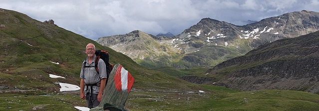
Trying to get back to our original plan, we got a bus to Lucknerhaus (1920m) and climbed up to the Salm-hütte (2544m) via the Glorer Hut, and a trip to the Medelspitze to watch marmots.
- 10km, 869m up, 140m down, 4hrs
- GPX Route: https://www.haroldstreet.org.uk/routes/download/?walk=6008
- https://www.alpenverein.at/salmhuette/
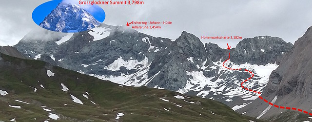
Day 5: Failure to get up Hohenwartscharte (3,182m)!
We set off from the Salmhutte to climb the glacier & via ferrata of the Hohenwartscharte (3182m). The weather was foggy and was forecast to get worse quickly.
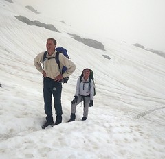
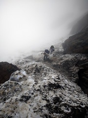
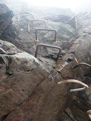
We crossed the snow onto increasingly steep ice (Grade 1). At the top of the ice / bottom of the via ferrata (graded D) there was not a lot of space to get our gear on, and worse still, the iron staples that formed a huge vertical ladder were far too thick to get our via feratta clips around, and were otherwise unprotected. Even so, i climbed the first horrible vertical section, eventually finding a cable to clip onto several metres up. I set up a belay at the top of the vertical section (3,133m), and looked up at 45 degree wooden steps continuing upwards apparently indefinitely.
Then the weather started to turn quickly. Out of the gully, i was no longer protected from the strong gusty winds, and it started to drizzle. By the time i got into my jumper and waterproofs, i was quite cold, and my buff blew away, so we all decided to sack it off. i descended the shit scary ladder again – Scharte by name scharte by nature.
Back to the Salmhutte for a nice slice of warm humble pie and coffee.
Who’d have guessed it! The weather cleared up and so we decided to take a contouring route around to the Stüdlhütte. We crossed the Pfortscharte (2828m) where we met three dutch women struggling with the crappy path and we helped them cross some ice patches over the course of the afternoon.
The storms finally arrived at 5pm just as we arrived at the hut. All in all, a bit of an epic day out.
- 10.7km, 957m up, 812m down, 8 hrs!
- GPX Route: https://www.haroldstreet.org.uk/routes/download/?walk=6009
- https://www.tyrol.com/things-to-do/sports/hiking/refuge-huts/a-stuedlhuette
Day 6: Lucknertal
The weather forecasts failed to give us sufficient windows for another summit attempt, and we were probably too tired to try anyway. So we decended via Lucknerhutte and the Luckner Hause back to Kals. We were finally rewarded with a good view of the Grossglockner too!
- 11.4km, 1m up, 1479m down, 5:30hrs
- GPX Route: https://www.haroldstreet.org.uk/routes/download/?walk=6010
Day 7: Dorfertal to Kalser Tauern Hauser
We thought we’d see what we missed by skipping day one of our plan and walked up the Dorfertal to Kalser Tauern Hauser
- 13km, 355m up, 243m down, 4hrs
- GPX Track:https://www.haroldstreet.org.uk/routes/download/?walk=6011
More Pictures…
From here…
Useful Links
Author: Phil Newby





Leave a Reply